Lade Informationen...

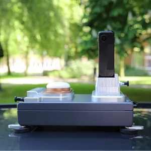
The SmartPano Elite is designed for survey-grade mobile mapping applications where accuracy, reliability and performance are essential.
The system combines a Ladybug 5+, Ladybug 6 or DuxCam G2S panoramic camera with a Hesai XT32 or Ouster OS1-128 LiDAR sensor. Advanced GNSS and INS integration provides accurate positioning, precise synchronisation and stable heading information throughout the data capture process.
With RTK and PPP support, the SmartPano Elite delivers survey-grade positioning accuracy for applications in surveying, infrastructure, construction and asset management.
The system includes an onboard GPU computer for real-time edge processing and field monitoring. Its rugged, foldable roof-mount design enables efficient deployment, transport and operation in demanding field environments.
The SmartPano Elite is part of the complete Smart Delta mobile mapping workflow:
Together, these solutions provide an integrated workflow from survey-grade data capture and processing to visualisation, measurement and final geospatial results.
Key benefits